Andorra is divided into 7 parishes (municipalities): Andorra la Vella, Escaldes-Engordany, Encamp, Canillo, Ordino, La Massana and Sant Julià de Lòria. Each parish has its own Common (municipality) and a distinct identity: from the commercial capital (Andorra la Vella) to the tranquil valleys of Ordino or the ski resorts of Canillo. This guide explains what to see and do in each of the Principality's 7 parishes.
Key data (2025–2026)
- Number of parishes: 7 (Andorra la Vella, Escaldes-Engordany, Encamp, Canillo, Ordino, La Massana, Sant Julià de Lòria)
- Most populated parish: Andorra la Vella (~22,000 inhabitants)
- Largest parish: Canillo (121 km²)
- Smallest parish: Andorra la Vella (11 km²)
Source: Department of Statistics of Andorra
Last update: May 2026. The information in this article is regularly checked against official sources from the Government of Andorra.
The territorial organization of Andorra is structured into 7 parishes: Andorra la Vella, Escaldes-Engordany, Sant Julia de Lòria, Encamp, La Massana, Ordino and Canillo. Some parishes have smaller territorial constituencies, but are of minor importance. Thus, Ordino, La Massana and San Julian de Lòria are divided into quarters, and the parish of Canillo is distributed in neighborhoods. Each parish receives the name of the nucleus of population that makes capital.
Traditionally the parishes of Encamp, Canillo, la Massana and Ordino have been known as the high parishes, being in the valleys of the Valira Oriental and Valira Del North. So the others are called lower parishes, and central parishes to those of Andorra la Vella and Escaldes-Engordany, although the latter two are less frequent.

The parish exercises both ecclesiastical and civil functions. As a civil jurisdiction it has the name of Common (commune). Each of the jurisdictions has a chamber, the Council of the Come (Community council) made up of the major consul, the minor consul and 8 to 14 community councilors elected every four years by universal suffrage among the Andorran population, which is minority in the country due to a very restrictive nationality acquisition policy. The administrative system of the Principality of Andorra is quite decentralized, with which the different comes together they have more power than the central government itself.
Andorra la Vella
Andorra the Old (Andorra la Vella) is the main parish, the smallest and the one with the most population insider. Its inhabitants are distributed in three urban centers: Santa Coloma, the old village of La Margineda and Andorra la Vella, the capital that gives its name to the parish.
Its average altitude above sea level is 1,022. It has an area of 12 km2 and a population of about 22,000 inhabitants, of which approximately 19,000 are from the capital and about 3,000 from Santa Coloma, while the population of La Margineda is very small.
A curiosity of the city of Andorra la Vella is that, being at an altitude of 1.013 meters above sea level, it is the state capital located at the highest altitude above sea level in all of Europe. Furthermore, since Santa Colo ma and Escaldes-Engordany are attached to this city, together they form an agglomeration of about 36,000 people. It should also be noted that until 1978 Escaldes-Engordany was included in this parish, and in 1978 they separated into the current two.
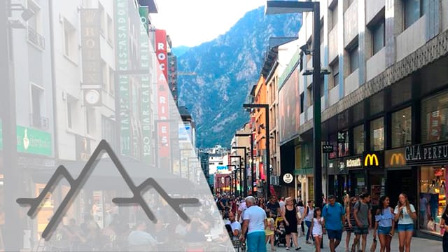
The famous Andorra shopping street, which is now pedestrian, it crosses the capitals of the parishes of Andorra la Villa and Escapes Engordany along the avenues of Meritxell and Carlemany respectively, being an easy route for an afternoon of shopping and a walk through the country, since it also concatenates beautiful squares and public spaces.
Escaldes-Engordany
Born, as we have mentioned before, in 1978 from a split in Andorra la Vella, Escaldes-Engordany is the second largest parish in population with about 14,000 inhabitants. Located in the heart of the country, right at the confluence of the two rivers ; Valira, it is formed by two important urban centers, that in their origins were separate and well differentiated, one on each side of the river: The Scalds (Escapes) and Fattening (Engordany). These two towns were united by the Scheldt-Engordani Bridge. With the growth of both cities, they formed a single population.
From medieval times the texts speak of small inhabited nuclei: Engordany, Else Vicars d’Engordany, ex Fewer and Engolasters. Despite being all under the Comical de Escapes Engordany, these nuclei maintain their name, being Engolasters and Else Vicars urbanization in the mountain ranges from both mountains of the valley.
Of this parish, the historical difference between the two nuclei is quite peculiar, which still persists today. This difference is the existence of hot springs in Escapes, which led to its economic orientation towards tourist exploitation of said waters (hotels-spas, spas like the Caldea Thermoludic Center, etc.) while Engordany maintained its traditional agricultural and livestock character.
Sant Julia de Lòria
Saint Julian of Lòria (Sant Julia de Lòria) is the southernmost of the seven ; parishes ; of the ; Principality of Andorra. It is the lowest in altitude with 908 meters above sea level and the one that contains the border with Spain. It limits the north with the parish of Andorra la Vella; to the northeast with the parish of Escaldes-Engordany; and to the west, south and east with Spain. It unfolds at an altitude of between 850 and 2,600 meters.
Its formed by the town of San Julia de Lòria and six rural rooms (in Catalan, quarts) or parish subdivisions: Bixessarri, Fontanel, Auvinyà, Jerri, Ago, and Centers, in addition to other population groups such as Aixovall, Aixirivane total population of almost 9,000 inhabitants. The town of San Julian de Lòria is a population in full expansion, whose urban core is developed around the river bank Valira.
Its most important historical attractions are the Communal House (seat of the municipal government), the Romanesque church dedicated to San Julian de Lòria and San German and the old town. Furthermore, on the outskirts of this town to the south there is a strong shopping area with large stores, located going towards the Spanish border, such as the River Center Commercial, Sant Eloy and Punt de Trobada.
The naturlandia multi-activity theme park it is located in this parish, on the Rabassa mountain. It was opened in 2007 by the parish community with the intention of revitalizing the Rabassa Snow Field, the only cross-country ski resort in the principality. Naturlandia is divided into two levels, the first at a height of 1,600 meters and the second at a height of 2,060 meters. It has a school farm and an amphitheater for 700 people.
Encamp
Encamp is the parish that follows Escaldes-Engordany taking as a reference the Andorran-Spanish border. It has an extension of 84 km2, with which it is the third largest parish behind Ordino and Canillo. Its population is 13,000-14,000 inhabitants and it has an average altitude of 1,238 meters above sea level.
Of the six towns that previously formed the parish (Encamp, Treat, Mosque, Les Boys, Vila and Ex Pas de la Casey) only Vila and Ex Pas de la Casey are currently differentiated from the main nucleus, which includes the other four. While Vila is located a few kilometers from the main town, Ex Pas de la Casey is the border town with ; France ; and the only direct road access, being 25 km from Encamp. The Valira de Oriented river, which rises in the glacial lakes of Persons, crosses the parish parallel to the road towards Pas de la Casey.
Encamp has several Romanesque-style chapels and churches, and it is also highly visited in summer for its mountain trails, famous for the typical fauna and flora of Andorra. In this sense, the crossing point of the famous transpyrenean route GR-11. Lakes and forests populate the landscape of the Portals valley, from where many mountain routes of various levels suitable for all audiences (Rosa route, inter-parish road to Canillo, Newsagents lakes, Engolasters lake, Camped springs, etc.)
La Massana
The La Massana parish is located in the northwest of the Principality of Andorra and covers an area of 65 km. With a population of 10,000 inhabitants of which only 3,000 inhabit the main town of La Massana, this parish stands out for its great dispersion.
It consists of seven rural rooms or smaller entities: l’Almost, Any, Arousal, Arts, Pal, Simony and La Massana. It has in addition to the rooms six more small urban centers: Pool Del Pin, Escape, else Plans, Mas de Ribafeta, Xixerella and ex Pew.
It is in this parish where the Communal Natural Park of the Valley Del Comapedrosa, which gives its name to the highest peak in Andorra, Comapedrosa with 2,942 meters. In addition to this, there are numerous high-altitude peaks such as Rock Enrevessada, Racoferd, Medecorba, Pic Del Play de l’Estate and Cannons. There are also numerous lakes (else Formats, Les Troops, Montmantell and ex Negro) and pal and Arousal rivers, as well as the Valira Del North.
The double ski resort of Vallnord Pal-Arinsal it owes its name to both towns, which branch into Arts, standing in the middle of the mountainous area exploited by the station company.
Ordino
Ordino is the parish next to La Massana on the northwest side, and covers an area of 90 km in which only about 4,000-5,000 inhabitants live. Being the second largest and with so few inhabitants it results in a population density of 52.7 hab/km Its average altitude is 1,298 meters above sea level and the most important towns are: Ansalonga, Trans, Ex Serra, La Cortinada, Sports, Ordino, Segue and Songs, which constitute the least populated area of the country and they are arranged along the Valira Del North river.
Adjacent to the Comapedrosa Natural Park of La Massana and the Regional Natural Park of the Pyrenees of Ariègede France, in Ordino we can also find very relevant peaks such as that of Casamanya 2,739 meters and that of Font Blanca, 2,903 meters, as well as the cristina peak and pass, another nice hiking area.
Despite being the Andorran historical industrial center, Ordino is considered its cultural centerbecause there the Digest Manual (1748). This manual, inspired by the Encyclopedia franchise and enlightened thought, talks about the functioning of the Andorran state of the 18th century, its history and its uses and customs, which could be considered the laws that governed this small State before the 1993 constitution. The author was Ordained Antonio Fiber and Russell.
Moreover, it is categorized by many as «the most beautiful town in Andorra» For its peculiar cobbled center and traditional style, and it is in this parish where the ordino-Arcalís ski resort, where we can find “la coma d’Arcades”, the usual end of the stage in the tour de France.

Canillo
Finally, we reach Canillo, the largest of the parishes, with 121 km2 and the furthest from the border between Spain and Andorra. It is made up of the towns and urban centers of Almost, Canillo, Ex For, Ex Tarter, Ex Vicar, Else Plans, Inches, Meritxell, Prats, Ransom, Solder, Border de Envalira, San Pedro, Armand and Dollars. As we see, a large number of cores with a total population of 4,000-4,500 inhabitants of which about 2,000 live in Canillo, the capital. Compete down with Ordino for his low population.
This parish is the highest, with 1526 meters above sea level on average. That is why it is a parish where you can fully enjoy the sun, the snow and the mountains. The weather is cold and dry, and snow covers the tops and mountains during the winter months.
In addition to numerous historical buildings such as the; sanctuary of Our Lady of Meritxell, patron saint of the Principality of Andorra, in Canillo are the Andorra Ice Palace, with more than 8000 me including a olympic-size ice rink, and the rock engravings of rock de Les Bruises.

Also in the parishes of Canillo and Encamp you can visit Grandvalira, the largest ski resort in Andorra and one of the largest in Europe, with 210 ski able kilometers, in which snow is guaranteed throughout the season. You can also see Andorra from the Rock Del Query viewpoint, a platform 20 meters long and 20 meters high, 10 of which are hanging off the cliff and with wonderful views of the Canillo valley.
Concord Ground
We could not finish this article without mentioning the Terrain of Concord. It is a territory historically disputed by the parishes Andorrans of Canillo and Encamp, which currently operates the Grandvalira ski resort. It is the area of 15.6 km2 between the valley of Alta Valira, in the parish of Canillo, and that of the Portals, in the parish of Encamp. Its highest peak is the “tosa” of Encampadana, at 2,476 meters and still continues to be disputed by the parishes.
We also remind you that if you want to come to live in this fabulous place like the Principality of Andorra, the country of the Pyrenees, you can contact us by clicking here. We offer them comprehensive and total support, from submitting and solving all the necessary procedures to open a business or obtain residency in Andorra until guiding them in the life and day to day of the country. May read all the advantages of establishing yourself in this country here.
Official sources
- Statistics per parish — Department of Statistics of Andorra — Department of Statistics
- Comú d'Andorra la Vella — Comú d'Andorra la Vella